girlonarope

About girlonarope

https://girlonarope.com/about-me/

Micro Death Hollow, Escalante, Utah

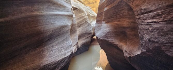
At the beginning of May, our friend Sri came to visit Utah and proposed a weekend in Escalante. We jumped at the chance to take our new RV trailer out for a test run. We drove up on Friday night and found a fantastic dispersed RV camping area right off Hole in the Rock road. There were a number of RVs already there, but we had privacy and it was extremely quiet. The next morning we met up with some friends on a balmy day and headed into Micro Death Hollow, a great canyon with a scary name. This is a short canyon that definitely packs a punch, depending on water levels. Several members of our party did not have wetsuits, so we were hoping that conditions were not too wet but planned for an early exit via the sneak route if needed. No permits are needed and beta [...]

By |2024-07-09T22:22:09+00:00May 5, 2024|canyoneer, remote canyon, Utah|0 Comments

Lower Death Hollow, Escalante, Utah

Lower Death Hollow is one of the most beautiful river hikes in the Escalante area featuring clear, calm water and beautiful plants. We also had some amazing wildlife encounters in the river corridor. To access this hike, you can choose to do a strenuous 3+ day backpacking route, a moderately strenuous day hike or a technical canyoneering route down to the river through Micro Death Hollow, which is what we decided to do. Most people choose the day hike option, which starts at the Micro Death Hollow trailhead and is in fact the exit route for the canyon. This in and out route is down a steep slickrock bench which involves finding an appropriate slope to descend down to the Escalante River, at which point a well-worn social trail emerges along the banks of the river. Walk upstream a short distance until you see the confluence with Death Hollow, [...]

By |2024-08-14T17:04:28+00:00May 4, 2024|hike, hikeaneer, remote canyon, Utah|0 Comments

Fat Man’s Misery, Zion NP, Utah

Fat Man’s Misery is one of the ultimate hikeaneering adventures in Zion NP. Located just outside the park, this route features a grueling but beautiful hike into the Zion backcountry and requires decent navigation skills to get where you’re going and back out. If there was ever a route that could be considered going uphill both ways, this would be it. No permits are required for this canyon aside from the entry fee into Zion. Canyon beta is available here: Canyoneering Misery (Fat Mans) East / West Forks - Zion East Side - Road Trip Ryan It was a balmy day at the end of April when we met up early with our friend Brian Connelly at a pullout near Checkerboard Mesa in Zion NP. The weather was just right – highs around 70, which would mean we could warm up in the sunny stretches between the wet canyon [...]

By |2024-06-28T15:40:25+00:00April 28, 2024|canyoneer, hikeaneer, Utah|0 Comments

Round Valley Draw, Grand Staircase-Escalante NM, Utah

Round Valley Draw is a wonderful intermediate hike into a marvelous slot canyon in the Grand Staircase-Escalante NM. Located about 15 miles south of the tiny town of Cannonville, Utah, the trailhead is accessible off the Cottonwood Canyon Road, which is usually well-graded and accessible to passenger vehicles when dry but difficult if not impassable when wet. This is a fairly remote area in general, but this hike is very close to Willis Creek, so it’s a great idea to combine them for a full day. Although you are heading into a tight slot canyon, be careful in the summer months as it can be extremely hot out. I recommend doing this hike in the fall, spring or winter months when temperatures are more pleasant. There are several reasons for why I would deem this an intermediate hike: to get into the canyon, there are two obstacles that require [...]

By |2024-06-19T23:17:22+00:00April 21, 2024|hike, remote canyon, Utah|0 Comments

Averett Canyon and Willis Creek Slot Canyon, Grand Staircase-Escalante NM, Utah

Water in the desert is a magical occurrence, especially if it’s fresh and flowing. One of our more pleasant local hikes on a lazy spring day is Willis Creek Slot Canyon, located right off Skutumpah Road in the Grand Staircase-Escalante National Monument. Specific information on how to find the trailhead is available here: Willis Creek Narrows | Easy Slot Canyon Hike | Visit Utah. Unlike most of our adventures, this is a family-friendly hike, appropriate for all ages, walking down a mostly flat, gently flowing creek. There are three sets of narrows to see, spanning a little over a mile each way. If you venture to the end of the third narrows, you will find yourself at the confluence with Averett Canyon, the other subject of this post. Willis Creek holds a special place in our hearts as it was the first slot canyon we ever entered, many years [...]

By |2024-06-06T03:26:41+00:00April 14, 2024|hike, hikeaneer, Utah|0 Comments

Portal Canyon, Virgin River Gorge, Arizona

The Virgin River Gorge, known as the VRG, is a place of transitions and contradictions. It is the intersection of the Colorado Plateau and the Mojave Desert, between sandstone and limestone, between an incredibly arid climate and the Virgin River flowing through it, between remote wilderness and nearby civilization. Located between St. George and Mesquite, the VRG is accessed through I-15, one of the most expensive highway projects ever constructed. This section of highway is a challenging drive in the best of conditions due to an extremely curvy road, small shoulders and surprisingly high speeds. Add in high winds or darkness and the fact that there is no cell signal in most of the Gorge and the drive can become somewhat nerve-wracking. There are several technical canyons in the VRG, accessible through small pullouts off I-15, if you know where to look. This area is popular in the winter [...]

By |2024-06-05T05:04:10+00:00April 7, 2024|arizona, canyoneer|0 Comments

Rim Shot, Moab, Utah

It was the last Sunday of March, and we woke up to a blizzard. We were staying in Monticello for the weekend to meet up with friends and run some canyons in Moab. The day before, Mike Bilotta had taken us through the incredible Fiery Furnace. Today, the weather forecast was extremely iffy but supposed to be clearing up around 11am. We ate breakfast and packed up to head to Moab. The canyon we had selected for Sunday, Rim Shot, was short and open, more of a cliffaneering route than a canyon, with very low risk of flash flooding. No permits are required for this canyon and beta is available here: Rim Shot - ropewiki. We convened with our party at 11am in a parking lot along the highly scenic Colorado River corridor. As soon as we arrived, the weather decided to really pick up and give it one [...]

By |2024-06-03T03:44:25+00:00March 31, 2024|canyoneer, Utah|0 Comments

Krill and Lomatium Canyons, Arches NP, Utah

Imagine, if you will, a vast maze composed of red sandstone spires, deep vertical cracks, ramps and fins taking you up and down what look like blind passages, incredible arches and ancient juniper trees lifting their branches to the sky. This, my friends, is the famous Fiery Furnace, located in Arches NP near Moab. The Fiery Furnace is one of the most popular hikes in Arches and requires a permit that can be obtained one week in advance. Permits are available at: Self-Guided Fiery Furnace Exploration - Arches, Arches National Park Tours - Recreation.gov, at 8am MDT. These permits go very fast, usually within a few minutes, so if you want one, plan on being at your computer at 8am MDT. Permits need to be picked up in person at the Arches Visitor Center the day of or day before your hike, which includes watching an informative video and [...]

By |2024-05-09T03:55:38+00:00March 30, 2024|canyoneer, Utah|0 Comments

North Coyote Buttes (AKA the Wave), Arizona

North Coyote Buttes, also known as “The Wave” is truly one of the most magical places I have ever visited. Each time we go, there are new wonders to explore. Everything from dinosaur tracks to incredible lace rock to intricately cut alcoves with sand dunes can be found here. This March, some of our canyoneering friends came to visit from out of state. Due to threatening weather, we took them to White Pockets and played the daily lottery from the top of the butte. Fortuitously, our friend Jess won the lottery, so we got to go for our fifth time and play tour guide. Let’s start with the basics. The Wave is one of the most difficult permits to obtain in the United States. Only 64 people per day are allowed to visit, with thousands of entries to the lottery. There are two types of lotteries, daily and advance. [...]

By |2025-01-14T01:47:20+00:00March 13, 2024|arizona, hike|0 Comments

White Pocket, Arizona

The Vermillion Cliffs National Monument, on the border or Utah and Arizona, is one of the greatest geological treasures in the United States. Deep within its heart, hidden in a maze of sandy roads are three incredible sites, all located within several miles of each other: The Wave (North Coyote Buttes), South Coyote Buttes and White Pocket. Of these three sites, White Pocket is the only one currently accessible without a permit. Many years ago, on our first trip to the southwest, my husband and I booked a tour of White Pocket and it proved to be the gateway drug that led to us eventually moving to southern Utah. So be careful! A trip here might just change your life 😊. Located in a fairly small area, you may want to allocate three to four hours for the hike. The drive might take two or more hours each way. [...]

By |2024-03-21T02:12:00+00:00March 11, 2024|arizona, hike|0 Comments
Go to Top